Östervallen
 View of Östervallen's Old Town with the harbour of Oxniehärad in the background. | |
 Flag |
 Coat of arms |
| Location | |
|---|---|
| File:OVloc.png | |
| Country | |
| Region | Östervallen |
| Foundation | before 5000RH |
| Government | |
| Type | Democratic |
| Body | Stadsfullmäktige |
| Physical | |
| Elevation | 15 m |
| Time zone | UTC-3 |
| Population | |
| Total | 2,759,010 |
| Rank | 1st place |
| Demonym | Vallbo |
Östervallen is the capital and largest city of Vittmark. It is located on the north coast of Stoldavia at the Bay of Shields. The city is one of the most historically important places in Anaria, being founded over 2500 years ago and serving as capital for the Orkanan Realm of Stoldavia, Greater Stoldavic Empire (summer capital) and now Vittmark.
Etymology
Östervallen derives from "Östomvallen" which literally means "east of the city wall". This refers to the new fortification built east of the medieval town of Kungsvik, a government complex that was built to function as capital for the Greater Stoldavic Empire in XX. Gradually, the Old Town, government complex and New Town built east of the fortification all were indicated by the name Östervallen.
Inhabitants are usually referred to as vallbo, meaning "people living inside the city walls". This term is slightly misguiding, since the New Town never had any city walls but was defended by fortifications on top of Klippan instead.
For languages that don't use the "ö" as a letter, the official spelling is Oestervallen, with the proper pronunciation being Usterwallen. The older Hallish name Oswald is hardly used these days, but can still be used as synonym. The suffix ~wald is however referring to a forest ("wood") which etymologically speaking is completely wrong. The correct Hallish name would be Eastwall.
History
There is an ongoing debate if the foundation of Östervallen can be set before the foundation of the Orkanan Realm in 5056RH. At the end of the realm age, the capital was destroyed completely in order to prevent it from playing a future role as a focal point for Orkanan and Stoldavic culture. It is unclear if there has been a continuous settlement in this area, or that the fishing hamlet of Kungsvik that was first mentioned in chronicles in 6456 was a new settlement.
The remnants of the realm capital of Skiöldavik can be found in an unbuilt archaeological site called Heligas just south of the Old Town. Rubble from the ancient capital has been used to construct the Old Town and its city walls, when Kungsvik was granted staple port rights withing the Union of Skara in the 6600's. Kungsvik was a so-called lower town, located on the shore plains, while Skiöldavik and Heligas are located on top of Klippan. The foundations of the Dämmanö fortress, including water mills and drinking water facilities, date back to the Orkanan Realm.
In the early 6900's the first effort was made to build a fortification on nearby Lövön. After the marriage of Prince Råger of Mellanhand with Princess Caroline Varen of Ostburg in 6934 and the association of the Kingdom of Thronreich in 6940, the Greater Stoldavic Empire (or Second Realm as it was called at the time) needed a capital for the northern half of the nation. A planned government center with an imperial palace, surrounded by earthen walls, was constructed from 6941 on. East of the complex, a modern military base and some merchant harbors were built in the so-called New Town, stretching itself out towards the fortresses of Borgö in the east and Söderporten in the south. The river Fyrirå became the city's outer border.
After the fall of the empire in 7204, Östervallen became a city state in the border region between Ådalen and Liden, benefiting from the trade between these rival nations that only could take place here. Vallbo were seen as neutral parts, since Lidenites and Ådalers didn't want to trade directly with each other. City management was headed by the Av Kulla family, but most often outsourced to a local board of trading stims and land owners. However, the conflict between the three main post-imperial kingdoms of the region (besides Ådalen and Liden also Hagen) regularly took its toll on the city when one of the parts tried to gain control over the merchant city state.
It was in this difficult setting Östervallen entered the Pan-Anarian War involuntarily. While shipyards in nearby ports and harbours started building naval vessels for the different belligerents in the conflict, Östervallan manufacturers wanted to become a part of the lucrative market. It meant that the shipyards and docklands became a target, resulting in Östervallen being shelled through maritime attacks four times in the 7520's to 7540's. The situation deteriorated when Ådalen and Liden both tried to gain control over the city, firing artillery at each other from opposite parts of the city. It became clear that the defensive structures around Östervallen, dating from the late 7100's, were no match for modern warfare of the early 7500's.
Even after the Pan-Anarian War ended in 7554, the hostilities between the neighbouring states continued, damaging buildings and facilities in Östervallen in the process. The conflict ended in 7564 with the signing of the Treaty of Nisipari, gathering the fighting parties in a loose economic confederation with a thin layer of central administration being located in Östervallen. The first elected monarch, King Karl av Kulla however turned the confederation into a federation within two years, but opponents of the process assassinated him and the crown prince on the stairs of Borgö Palace, seat of the city government in 7566.
The city underwent a reconstruction period with the New Town being modernised, railway lines getting connected through the city, harbour development and the foundation of two garden cities on the Lidenite and Ådalish side of the city, Åstunda and Källby respectively. Horse drawn tramways were replaced by electrically powered cable cars, providing connectivity through the entire city with its demanding geography.
In the early 7600's, after the Pan-Stoldavic War that led to even more destruction, the shantytowns on top of Klippan, forming about half of the built-up area of the time, gradually got replaced with modern buildings following a blueprint master plan for a new infrastructure network. Eleven high-rise constructions called "The Eleven Sisters" provided links between the lower and upper city parts, which until then had been limited to 3-4 roads and some donkey paths. These buildings, erected between 7606 and 7618, are currently seen as the most important measure to create a single urban landscape in the city that previously had been divided into clearly separated ethnic enclaves.
Urban landscape
Up until the 77th century, the city form was mainly elongated in an east-west direction, following the coastline of the Bay of Shields and the Klippan divide between the higher and lower parts of the city. The typical geography of the region with (former) islands, two rivers and a cliffside has resulted in a multifaceted city landscape with very different and identifiable parts.
Old Town
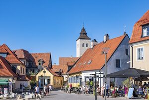
The old town still has its medieval structure, including an almost intact city wall from the late 6800's. The street pattern is irregular with buildings in natural stone and orange tile roofs. Today it's one of the most popular places to live and has a vibrant restaurant and shopping culture. Just south of the walled town is a modern extension with a large railway station built in the 7580's, but most of it is the unbuilt archaeological site Heligas that covers the ancient capital of Skiöldavik. Even though today this part of the city is known as Old Town (Gamla Stan) its original names include Gamlevik and Kungsvik.
Östvallen
The Östvallen complex is a planned government center inside earthen walls and ramparts with a grid street pattern, measuring about 500 by 800 meters on the island of Lövön. It was built as an integral city with its own city walls, serving as the summer capital of the Greater Stoldavic Empire. Östvallen is considered a city within the city and has its own exemptions from the rule by the City State.
Östvallen is where most federal government institutes are located today, like the Royal Palace, the federal parliament Förbundsdag, the federal senate Förbundsting but also the Trossamfundsala functioning as the central gathering place for Mellanhand Orkanan in Vittmark. Most of the university faculties have moved out towards the campus in Rustningen, but some university buildings are still in use here as well. After the war damage from the late 7500's and early 7600's, Östvallen was carefully renovated into an architectural style resembling the heydays of the Greater Stoldavic Empire. Apart from a busy place for the federal administration, it is a popular tourist destination.
New Town
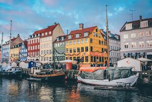
New Town is probably the most characteristic part of Östervallen. Built between the Östvallen complex and the river Fyrirå, it contains som of the more iconic areas of the capital, like the Borgö castle complex, the busy Månstatorg square facing the West Station, the old trading district of Nyhamnen, the former military barracks in Härstaden, the inner fishing harbour of Göstavik and the urban renewal area of Varvstaden. Even though the city structure is basically the same since the 71st century, it has a mix of buildings from all era's. New additions like the combined music theatre and residential block Yumas fit within the urban fabric, showing that Vittmarker architecture is much about creating public spaces and functional buildings. Many of the neighbourhoods still carry the names of the stims originally owning the real estate here, since the city board historically handed out plots of land and real estate to high ranking military and local nobility in order to keep development of the New Town going.
Mellerstaden
Mellerstaden used to be a worker's area just south of the New Town, but during the 77th century it has been rebuilt as the central business district of the Vittmarker financial and services industry. At the time there were huge protests about this urban renewal project, but most of the buildings in the area were in a too shabby state to have any future. City planners avoided making this a mono-functional part of the city with only offices and services by mixing in residential, shopping and restaurants in the same buildings.
Oxniehärad and Källby
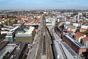
Oxniehärad almost feels like a separate city just west of the Old Town. This used to be the Ådalish settlement outside the city walls, dating back to the days when Östervallen was a city state. even today, it is a patchwork with active harbours, small industries, railway yards giving it a much more blue collar feeling than much of the rest of central Östervallen.
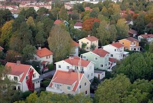
Källby on the other hand was built as a separate garden city on top of the cliffs south of Oxniehärad. The layout for Källby incorporates extensive parkland and open spaces. While most of the dwellings were built for extended families in the Mellanhand Orkanan tradition, today many of those buildings have been refurbished into apartment buildings like urban villa's. Historically, much of the late 76th century manufacturing and warehousing was located here. Much of it has been redeveloped into services, shopping and residential, but there's quite some industrial activity left in the area.
Åstunda
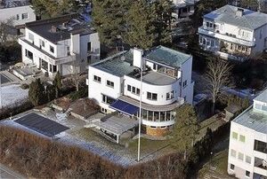
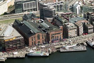
Åstunda was built as the Lidenite answer to Källby, a garden city built around a railway station just east of the Fyrirån river. The docklands north of the railway were the main hub for trade during the turn of the 77th century. But most cargo handling moved further east and to adjacent cities like Kletudde, resulting in a large scale redevelopment. Today, Åstundahamn presents Östervallen's modern skyline with high-rise offices and residential skyscrapers. South of the railway line, much of Åstunda still has the same vibes as 100 years ago when the area was constructed.
Grönåsen
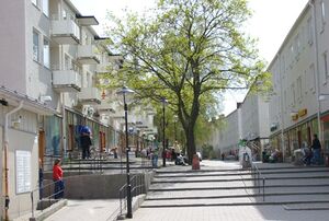
The Grönåsen area was built mainly in the 7640's and 7650's on a metropolitan line towards the southeast. Smaller existing settlements were incorporated and a mix of 3-4 storey apartment buildings and row houses were built around stations on the line: Höksätra, Hagängen, Fårdalen, Högsta, Sturemossen and the preliminary terminus for the Metropolitan railway in Bagarby. These areas would have 5,000 to 10,000 inhabitants each. The apartment buildings were originally equipped for an extended family occupying an entire entrance or stairway with 4-6 connected apartments each. Today many of these have been separated into individual dwellings, but there's a trend of extended families moving in and reconnecting them going on at the moment.
Söderstaden
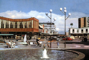
Söderstaden is the collective name of the suburbs being built on the new metro line to the south, with areas like Rustning, Hasselberg, Väringsborg and Norsby. Apart from Rustning, which was an airport until 76XX, these areas were built as so-called BAS-areas (bo- arbete - service meaning "living - work - service") around metro stations with all of the daily functions at walking distance. This typical planning principle from the 7650's was applied to other cities as well, but Söderstaden shows the best examples. The whole development was a bit more large scale than on Grönåsen, with areas being planned for 15,000 to 20,000 residents per station and apartment buildings in 6-10 storeys.
Transportation
- Main article: Transportation in Östervallen