Skiöldavik

Skiöldavik (also spelled Skiuldawick, Sciuldawic or Shuldawick, often called Shieldwick in Hallisian) is the historical capital of the Orkanan Realm of Stoldavia. The city was thoroughly destroyed during the fall om the empire in 5713RH, to such a degree that the knowledge about the exact location was lost from the joint regional memory for nearly two millenniums. Today it is clear that Skiöldavik was located in the exact same location as Vittmark's current capital Östervallen. The remaining ruins can be found in an unbuilt area called Heligas just south of Östervallen's Old Town. Much of that old town has been constructed between the 58th and 63rd centuries with building material from the archaeological site.
Etymology
The name Skiöldavik literally means "Bay of Shields", but over time, the suffix ~vik has become synonymous with "settlement" as well. The name refers to the bay of the Stoldavic Sea north of the city, which reflects the fact that the city was in charge of the entire region already early in its history.
Reconstructed history
TBA
Cityscape
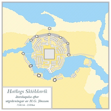
The city was located on a hill marking the geographical feature called Klippan on a peninsula between the Fyrirån river and the Northern Sea. In order to adapt the waterway for transport and building a reservoir for drinking water, a dam was built across the river at the city's eastern side. Somewhere around 5300RH large waterwheels were installed, turning the dam into an energy resource as well. Up to today, the Dämmanö waterworks are the oldest in the world, but there must have been earlier implementations of water power in the region in order to make a rather large scale implementation in Skiöldavik possible.
On the north side, a sea port was created at the western edge of the city. The city therefore also functioned as staple port for export of produce and timber from the inland to other coastal communities. But due to lack of archaeological research in the area, it is not known what this port looked like.
The Great Shield of Vind was the central shrine, approximately 280x280 m square and according to descriptions from visiting cultures it was a low pyramid with a centrally located dome building, probably raising itself some 65 m above the hill it was built upon. Most of the sand- and limestone from this pyramid was re-used as building material in the Old Town. The shrine is said to have been a recreation of the diversity of the known world, with botanical gardens, a zoo (including two aquariums) and an exhibition of foreign artefacts. The Klippan cliffs were levelled to make room for the large structure, a feature that still is visible in the western part of Östervallen's Old Town.
The city center had a circular structure, with the walled center measuring about 1100 m. The southern half was protected by the artificial lake with a water level of 22 m above sea level, the northern half had an earthen wall, which later was fortified with natural rock.
While many of the buildings in the center were made from locally produced sandstone, the city core of Skiöldavik must have been surrounded by urban dwellings in timber. Due to the building history of Östervallen during the last 6-7 centuries, hardly any evidence of this type of less urban building has been retrieved. Therefore the exact size of the city during the realm's heydays is still unknown. It is generally assumed that these dwelling might have stretched out a further kilometer to all sides, creating a city of 3-4 km in diameter. This is historically speaking the maximum size of a historical city where pedestrian traffic is the main way of transport.
Legacy and aftermath
The name Skiöldavik is connected to the Orkanan Realm of Stoldavia through the southern (mainland) Anarian contemporary name Regalis Stoldavica. As such, the name of the island of Stoldavia and the general indication of its culture and language group (also shortened to Stolvic) can be traced back to this city. During the age of the realm, the proper pronunciation was Shtshuldawi:k which led to the St~ spelling in mainland Anarian. Even the Stolvic Orderist Commonwealth and Stolvic Ocean are therefore named after the ancient capital of Skiöldavik.
The strategic location of the city during the age of the realm was confirmed centuries later, when the Greater Stoldavic Empire chose the same spot for its summer capital. That was before it was known that this was the location of Skiöldavik. Even today, the size and status of Östervallen as capital of Vittmark reflects the strategic importance and beneficial geographical circumstances.
The reservoir from the realm era is still present today. The Dämmanö fortress, built in the 69th century, is built upon the realm age foundation of the watermill that was present here. Even during the imperial age, the facility was used as sawmill, gunpowder mill, tinplate mill and graining mill, often with two waterwheels with different functions.
Most of Östervallen's Old Town was built with material from Skiöldavik ruins, even though the builders probably did not know about the origin of the material. The entire Old Town is protected by law, since every stone might have been a part of Skiöldavik and as such is considered archaeological evidence from over 2000 years ago. There are however no plans to research the building material by demolition, since the Old Town has a high cultural-historical value as it is.