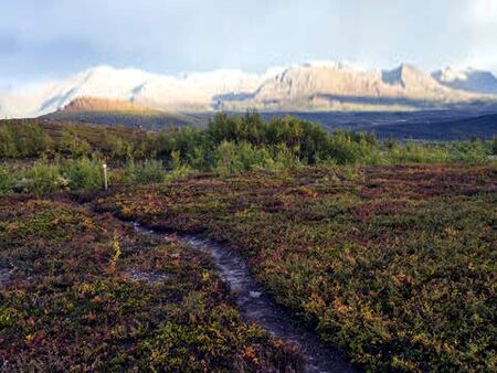
Gäddedevida

Gäddedevida is a highland plateau located in the Blue Mountains region of Sörmark, Vittmark. The area is as good as unpopulated, apart from some smaller railway hamlets among the Blue Mountains Railways, of which the one around the Ex. Bengt Gäddedevida station is the largest. Gäddedevida is protected as area of outstanding natural beauty, ecological and historical significance, even acknowledged by ICoN. It is most famous for being the home ground of the last remaining population of trunkbulls on Gotha.
Climate and landscape
The plateau is about 2000-2500 meters above sea level and measures about 2500 square km. Gäddedevida was a single glacier lake up to roughly 8,500 years ago, when the natural dam separating it from Övre Högdalen eroded away and the lake was drained within a very short period of time. Peat deposits spread out across the plains, covering lake sediments. Since then, small creeks and flows are continually changing the landscape during the melting season.
Due to its isolated location high up in the mountains, it has a cold and relatively dry land climate, with the possibility of snow all year round.
Flora and fauna
Main vegetation is scrub heath with few very hardy plants adapted to highest altitudes. The only trees growing here are usually bush-like birches and willows, measuring about 1 meter in height. This correlates with the average snow depth during the coldest winter period. The snow protects the plants from the worst of the cold blizzards. Other vegetation includes gorse, heather (erica and caluna), blueberry and lingonberry.
The area's animal life is like a remnant of the glacial ages, with unique species and subspecies living in and around the area. Some are typical for the entire Blue Mountains region, like the mountain fox (subspecies of the arctic fox), highland wolf (subspecies of the gray wolf) and Stoldavian ibex. Completely unique for the area are the legendary trunkbull and the equally rare muskox. Since the surrounding mountains lack any significant vegetation, the plateau serves as a feeding ground for most of the wildlife in the mountain region and shows a large ecological variety because of it.
Due to the lack of human population, the area is quite pristine without many roads. Apart from the Blue Mountains Railways crossing right through it, the Ryttsadel Trail as the old steamtruck road and Moa's Trail connecting to Kulla, there are hardly any roads, trails, tracks or paths in the area.
Human history
Gäddedevida has always been very difficult to cross due to the harsh climate, the ever changing landscape and the sheer size. It does however connect to northern Stoldavia through the next lowest mountain pass of Ryttsadel, which meant that humans always have tried to use the area as part of migration and travel routes.
During the Orkanan Realm small farmsteads for animal husbandry were located on the plateau. Some of them became Orkanan recluses after the Realms fall in the 51st century. At the time of the Greater Stoldavic Empire the area became more important as part of a land route between inland parts of the empire. The Ryttsadel Trail became a more permanent travel route with overnight cabins maintained by the imperial army. Even a path towards Kulla to the west became a more permanent route. When the empire fell, the routes still were used and maintained, especially as a link between Kulla and Östervallen.
Since it had hardly any population, the region did not fall under the jurisdiction of any nation state for centuries. It was mainly Kulla Stift maintaining the routes and as such introducing some form of administration, but the few people living here did not fall under any royalty or nobility. This made the region more attractive for religious minorities that did not want to subdue to new Mellanhand leadership in the northern regions like Hagen, Ådalen and Liden. Permanent settlement did not increase, but temporary residence towards more habitable regions in the Blue Mountains range occurred more and more.
Gäddedevida did get some strategic importance during the Pan-Anarian War, when the Wolgos occupied neighboring Mörenburg. Joint Anarian forces could attack the occupying forces from the back by crossing the highland plateau. The treacherous climate and conditions claimed many lives and made Gäddedevida notorious across Anaria. Many modern tales of rås appearing, both guiding soldiers as well as luring them into certain death, arose during this period. The liberated regions further south were surveyed for raw materials in order to support the war effort. Both coal and rich iron deposits were found.
This started a new episode in the history of the region, where iron rods and coal needed to be hauled across Ryttsadel pass towards the industrialised north. The Ryttsadel trail became the domain of steam trucks in the 7550's and 60's, with coal depots popping up along the route. The trucks could cover 100-150 km per day on the track, having to wait for trucks in the opposite direction at regular intervals. When Vittmark was founded, the region was included as a federal territory. With the help of Auresia, Halland and the local Fjällsta Stift, a railway connection was built in the 7570's. This provided more reliable cargo transportation between the north and south of the country.
After about a century, both the coal and iron reserves became more or less depleted, with the remaining raw material being to expensive to be retracted from the difficult terrain. Gäddedevida once more became a passage for people across the Blue Mountains primarily again. But the natural beauty and historical significance of the place also spurred tourism in the area. This is mainly concentrated around the Ex. Bngt Gäddedevida station, which is centrally located on the plateu.