Sörmark: Difference between revisions
mNo edit summary |
mNo edit summary |
||
| Line 13: | Line 13: | ||
}}'''Sörmark''' is the southernmost member state of [[Vittmark]], bordering [[Mörenburg]] to the south and [[Kulla Crown Domain|Kulla]] to the north. It was formed out of the former dependencies Friställen and Uppförsbackar as well as the former Mörenburger province of Inälvsdalen in 7570. According to the [[Treaty of Nisipari]] the intention was to include Kulla in the state as well, but that never happened. However, the state capital at formation became [[Kronsta]], which is located in Kulla. It took until 7680 until the last state government institution was moved to [[Lovis Bruk]], the current capital. | }}'''Sörmark''' is the southernmost member state of [[Vittmark]], bordering [[Mörenburg]] to the south and [[Kulla Crown Domain|Kulla]] to the north. It was formed out of the former dependencies Friställen and Uppförsbackar as well as the former Mörenburger province of Inälvsdalen in 7570. According to the [[Treaty of Nisipari]] the intention was to include Kulla in the state as well, but that never happened. However, the state capital at formation became [[Kronsta]], which is located in Kulla. It took until 7680 until the last state government institution was moved to [[Lovis Bruk]], the current capital. | ||
The state is located south of the Blue Mountains divide, with the high valleys being a part of the Reiki basin. The natural landscape is dominated by high mountain peaks, some of them exceeding 6000 meters above sea level. Arable land can only be found in the lower valleys, although there is still some animal husbandry on the alpine grasslands at high altitudes. Those two natural landscapes are separated by vast forests on the mountainsides. | The state is located south of the [[Blue Mountains]] divide, with the high valleys being a part of the Reiki basin. The natural landscape is dominated by high mountain peaks, some of them exceeding 6000 meters above sea level. Arable land can only be found in the lower valleys, although there is still some animal husbandry on the alpine grasslands at high altitudes. Those two natural landscapes are separated by vast forests on the mountainsides. | ||
Sörmark was rich in coal and iron finds, but coal mines got depleted during the 77th century. Even with the high energy proces of today, it is not economically viable to open new levels in the mines. But the richness in raw materials have played an important part in the wealth and economic structure of Vittmark today. | Sörmark was rich in coal and iron finds, but coal mines got depleted during the 77th century. Even with the high energy proces of today, it is not economically viable to open new levels in the mines. But the richness in raw materials have played an important part in the wealth and economic structure of Vittmark today. | ||
Revision as of 19:50, 1 February 2024
 |
 |

| |
| Country | Vittmark |
|---|---|
| Capital | Lovis Bruk |
| Area | TBA km2 km2 |
| Population | TBA |
| Density | TBA km2/km2 |
| Demonym | Sörmarker |
| Time zone | UTC-3 |
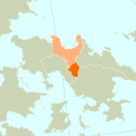
Sörmark is the southernmost member state of Vittmark, bordering Mörenburg to the south and Kulla to the north. It was formed out of the former dependencies Friställen and Uppförsbackar as well as the former Mörenburger province of Inälvsdalen in 7570. According to the Treaty of Nisipari the intention was to include Kulla in the state as well, but that never happened. However, the state capital at formation became Kronsta, which is located in Kulla. It took until 7680 until the last state government institution was moved to Lovis Bruk, the current capital.
The state is located south of the Blue Mountains divide, with the high valleys being a part of the Reiki basin. The natural landscape is dominated by high mountain peaks, some of them exceeding 6000 meters above sea level. Arable land can only be found in the lower valleys, although there is still some animal husbandry on the alpine grasslands at high altitudes. Those two natural landscapes are separated by vast forests on the mountainsides.
Sörmark was rich in coal and iron finds, but coal mines got depleted during the 77th century. Even with the high energy proces of today, it is not economically viable to open new levels in the mines. But the richness in raw materials have played an important part in the wealth and economic structure of Vittmark today.
Originally a sparsely populated area, the demographic background has been quite varied. Few Mörenburgers remained after the Pan-Anarian War, mainly those that opposed Stellist Orkanan and the upcoming Häversim. From the north an influx of freethinker settlers occurred as well, people from Hagen, Ådalen and Liden not wanting to commit to the Stifts of these predecessor nations to Vittmark. As such, the south became a free haven for people with alternative beliefs within the Orkanan tradition and different lifestyles. This was not free from fiction with the oldest Dölmer population, having settled here in the 72nd and 73rd centuries and owning all the arable land. The newconers had a tough time establishing an economic base, but living conditions and opportunities for self development improved a lot during the 7570's, when the landless Fjällsta Stift got the opportunity to acquire other means of production. Infrastructure and residential dwellings were built and maintained bu the freethinkers, helped by federal procurement.
From the 7540's, mining and the accompanying heavy industries slowly started to lose ground, with the last coal mines closing in 7679. Sörmark transformed towards small and medium sized companies, creating new niches in manufacturing (like heavy equipment) and service (like vehicle maintenance, real estate maintenance, entertainment). The state has a well developed agrofood sector with high level of technology aided agriculture and locally rooted preservation industries.