Negasi: Difference between revisions
m (→History) |
|||
| Line 12: | Line 12: | ||
| capital city link = Bogaye | | capital city link = Bogaye | ||
| capital city = Bogaye | | capital city = Bogaye | ||
| largest city = | | largest city = Elmisi | ||
| official language link = Negasi language | | official language link = Negasi language | ||
| official language = Negasi | | official language = Negasi | ||
| Line 35: | Line 35: | ||
| GDP total = 667.01 brillion | | GDP total = 667.01 brillion | ||
| GDP per capita = 7,614.49 | | GDP per capita = 7,614.49 | ||
| currency link = | | currency link = Negasi nauyi | ||
| currency symbol = | | currency symbol = | ||
| inequality index = | | inequality index = | ||
| Line 48: | Line 48: | ||
==History== | ==History== | ||
===Early history=== | |||
===Colonial period=== | |||
[[File:1886 bas obispo.jpg|thumb|left|Building the [[Ubani Canal]]]] | [[File:1886 bas obispo.jpg|thumb|left|Building the [[Ubani Canal]]]] | ||
The country was colonized for a while | The country was colonized for a while. The [[Ubani Canal]] was built during this period, beginning in 7563 and opening to ship traffic on December 15, 7574. | ||
===Post-colonial period=== | |||
Then it became independent and now it's today. | |||
==Geography== | |||
While predominantly located in Tharnia, Negasi is astride the division between Tharnia and Tzeraka, with a portion of the country's southwest located in that continent. The Vovodaran Sea lies to the west and the Tanga Moji Sea adjoins Negasi's east coast. The Koradium Mountains lie along a significant portion of Negasi's northwestern border. This region is home to three large lakes: Moto, Jelwa, and Tila. The Giganum Mountains are in the south. The Ubani Narrows lies between the two large mountain ranges. | |||
The Oluwa Islands are several islands off Negasi's west coast in the Vovodaran. There are several islands in the Tanga Moji, including Jabar, Set, Moriba, Salanko, M’basso, Torosso, Kolibelo, and Dyalinko islands. | |||
===Waterways=== | |||
* Babukar River | |||
* Ubani Canal | |||
* Some other significant rivers (prolly 11 or 12 of them) | |||
===Climate=== | |||
[[Category:Negasi| ]][[Category:Countries]][[Category:Tharna]][[Category:Tzeraka]] | [[Category:Negasi| ]][[Category:Countries]][[Category:Tharna]][[Category:Tzeraka]] | ||
Revision as of 22:19, 26 September 2023
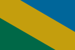
| Negasi Republic Jamhuriyar Negasi (Negasi) | |
| Flag | Coat of arms |
|---|---|

|

|
| Motto: | |
| Anthem: | |
| Locator map | |
| [[File:|300px]] | |
| Capital city | Bogaye |
| Largest city | Elmisi |
| Official language | Negasi |
| Other languages | |
| Ethnic group | |
| Religion | Naskel, Anur |
| Demonym(s) | Negasi |
| Government | |
| Government Type | Unitary parliamentary semi-presidential republic |
| Grand Chief | Rakanja Sadaka |
| Superintendent | Ayubu Owethu |
| Legislature | Superior Council |
| Establishment | |
| Area | |
| Total | 1,217,757.05 km2 |
| Water % | 4.39 |
| Population | |
| Total | 88,910,846 |
| Density | 73.01/km2 |
| Economy | |
| GDP (total) | Ꞡ 667.01 brillion |
| GDP per capita | Ꞡ 7,614.49 |
| Currency | Negasi nauyi () |
| Other information | |
| Driving side | right |
| Internet code | .neg |
Negasi, officially the Negasi Republic (Negasi: Jamhuriyar Negasi), is a country predominantly in southwest Thania with a portion in northwest Tzeraka. Its western boundary is the Vovodaran Sea and the Tanga Moji Sea lies to the country's east. The Ubani Canal links these two seas, forming a route for ocean-going vessels between the Ovestan and Phasian Oceans. The country has an area of 1,217,757 km2 (470,179 sq mi) with a population of 88,910,846.
History
Early history
Colonial period
The country was colonized for a while. The Ubani Canal was built during this period, beginning in 7563 and opening to ship traffic on December 15, 7574.
Post-colonial period
Then it became independent and now it's today.
Geography
While predominantly located in Tharnia, Negasi is astride the division between Tharnia and Tzeraka, with a portion of the country's southwest located in that continent. The Vovodaran Sea lies to the west and the Tanga Moji Sea adjoins Negasi's east coast. The Koradium Mountains lie along a significant portion of Negasi's northwestern border. This region is home to three large lakes: Moto, Jelwa, and Tila. The Giganum Mountains are in the south. The Ubani Narrows lies between the two large mountain ranges.
The Oluwa Islands are several islands off Negasi's west coast in the Vovodaran. There are several islands in the Tanga Moji, including Jabar, Set, Moriba, Salanko, M’basso, Torosso, Kolibelo, and Dyalinko islands.
Waterways
- Babukar River
- Ubani Canal
- Some other significant rivers (prolly 11 or 12 of them)