Kronsta: Difference between revisions
(Created page with "{{CityInfobox | Short city name = Kronsta | Full city name = Kronsta | City Photos = Kronsta.jpg | Photo description = TBA | flag = Kronstaflag.png | coa1 = Kronstacoa1png | Locator Map = Kronstalocatormap.png | country = Vittmark | region = Kulla Crown Domain | foundation = 7220 | government type = Residential democracy | government body = City Council | mayor = TBA | elevation = 1211 meters | total area = TBA km2 | urban area = TBA km2 | metro area = TBA km2 | time zon...") |
mNo edit summary |
||
| (One intermediate revision by the same user not shown) | |||
| Line 11: | Line 11: | ||
| foundation = 7220 | | foundation = 7220 | ||
| government type = Residential democracy | | government type = Residential democracy | ||
| government body = | | government body = Stadsfullmäktige | ||
| mayor = TBA | | mayor = TBA | ||
| elevation = 1211 meters | | elevation = 1211 meters | ||
| Line 25: | Line 25: | ||
It is connected to the rest of Vittmark mainly by railway lines like the [[Blue Mountains Railways]] (to [[Östervallen]] and [[Liden]]) and [[Friställebanan]] (to [[Ådalen]]) and has regional rail connections through [[Herrkullabanan]] and [[Grönspångsbanan]]. It is a rather small city, being the capital of the least populous member state of Vittmark. Until 7611, Kronsta even housed the administration buildings of neighbouring Sörmark, which made the town a double capital of two different member states. | It is connected to the rest of Vittmark mainly by railway lines like the [[Blue Mountains Railways]] (to [[Östervallen]] and [[Liden]]) and [[Friställebanan]] (to [[Ådalen]]) and has regional rail connections through [[Herrkullabanan]] and [[Grönspångsbanan]]. It is a rather small city, being the capital of the least populous member state of Vittmark. Until 7611, Kronsta even housed the administration buildings of neighbouring Sörmark, which made the town a double capital of two different member states. | ||
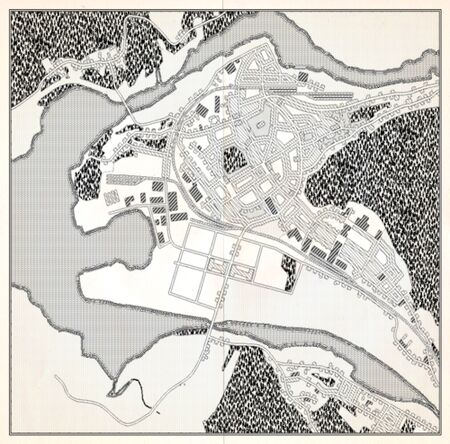
[[File:Kronsta old.jpg|alt=Unmarked survey map of Kronsta dating back to around 7570.|left|thumb|450x450px|Unmarked survey map of Kronsta dating back to around 7570.]] | |||
[[Category:Cities in Vittmark]] | [[Category:Cities in Vittmark]] | ||
Latest revision as of 16:01, 20 September 2024
| Kronsta | |
|---|---|
| File:Kronsta.jpg TBA | |
 Flag |
File:Kronstacoa1png Coat of arms |
| Location | |
| File:Kronstalocatormap.png | |
| Country | Vittmark |
| Region | Kulla Crown Domain |
| Foundation | 7220 |
| Government | |
| Type | Residential democracy |
| Body | Stadsfullmäktige |
| Mayor | TBA |
| Physical | |
| Elevation | 1211 meters |
| Total area | TBA km2 |
| Urban area | TBA km2 |
| Metro area | TBA km2 |
| Time zone | UTC+3 |
| Population | |
| Total | 163,020 |
| Density | TBA/km2 |
Kronsta is the capital city of Kulla Crown Domain, a member state of Vittmark. It is located south of the water divider in the upper Reiki basin at about 1200 meters above sea level. The city, whose name literally means "Crown City" was founded by the last emperor of the Greater Stoldavic Empire in 7220 at the inner bend of the Ställälven river with the intention of becoming the capital of his mountain state of Kulla. It would take until the 7500's until the town got that function, at that time forced by the geopolitical consequences of the Pan-Anarian War.
It is connected to the rest of Vittmark mainly by railway lines like the Blue Mountains Railways (to Östervallen and Liden) and Friställebanan (to Ådalen) and has regional rail connections through Herrkullabanan and Grönspångsbanan. It is a rather small city, being the capital of the least populous member state of Vittmark. Until 7611, Kronsta even housed the administration buildings of neighbouring Sörmark, which made the town a double capital of two different member states.
